Geofencing for pets is a GPS-based technology that creates a virtual boundary around a defined area and triggers an action – a notification to your phone, a cue to your dog’s collar, or both – when your pet crosses that boundary.
The concept is simple: you draw a shape on a map in a smartphone app, and the GPS collar worn by your dog continuously checks whether it is inside or outside that shape. When the collar’s position crosses the boundary line, the system responds. What happens next is what separates a basic geofence from a true containment system – and that difference determines whether the technology simply tells you your dog escaped or actually prevents the escape from happening.
Most pet owners encounter the term “geofencing” when researching GPS trackers or wireless dog fences, and the two concepts are often presented as identical. They are not. A geofence alert notifies the owner. A GPS virtual fence guides the dog. Understanding this distinction is the first step toward choosing the right safety technology for your pet.
How Does Geofencing Work for Dogs?
Geofencing works by continuously comparing the GPS position of your dog’s collar against the coordinates of a boundary you have defined in a companion app.
The process runs in a loop:
- The collar’s GPS receiver calculates its position using signals from orbiting satellites. Basic collars use a single satellite constellation (GPS only). Advanced collars like the Halo Collar 5 use 6 constellations simultaneously (GPS, Galileo, BeiDou, GLONASS, NavIC, QZSS), accessing up to 151 satellites for maximum accuracy.
- The collar checks its calculated position against the stored boundary coordinates. This check happens at the collar’s update frequency – once per second on basic trackers, up to 20 times per second on the Halo Collar 5.
- When the position crosses the boundary, the system triggers a response. In an alert-only system, that response is a push notification to your phone. In a containment system, the response is a graduated cue delivered directly to the dog through the collar.
The collar transmits its position data to the app through a cellular (LTE), Wi-Fi, or Bluetooth connection. This connectivity is what enables real-time tracking on your phone and what allows the system to send you alerts when a boundary event occurs. For a deeper look at how GPS location tracking operates within a smart collar, the Halo features page explains the full technology stack.
What Is the Difference Between a Geofence Alert and a Virtual Fence?
A geofence alert tells you the dog left. A virtual fence tells the dog to come back. This distinction is the most important concept in pet geofencing, and most guides treat the two as the same thing.
Pet geofencing operates at three levels, each providing a different degree of safety:
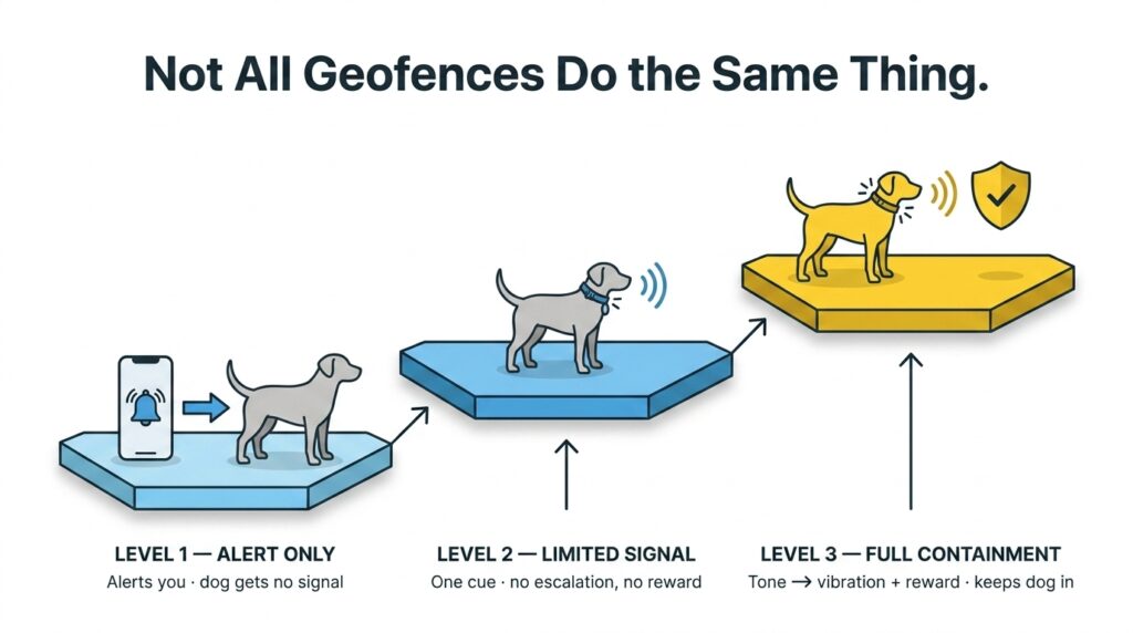
Level 1 – Geofence alert only. The collar detects a boundary crossing and sends a push notification to your phone. The dog receives no signal. By the time you see the notification, open the app, and respond, the dog may be hundreds of yards away. This is a monitoring tool, not a containment tool. Trackers from Tractive and Fi operate at this level.
Level 2 – Geofence with collar feedback. The collar detects a boundary crossing and delivers a single cue (a beep or vibration) to the dog, while also alerting the owner. The feedback gives the dog a signal, but there is no escalation if the dog ignores it and no positive reinforcement if the dog turns back. Some mid-range GPS collars operate at this level.
Level 3 – GPS virtual fence with containment. The collar detects the dog approaching the boundary and delivers graduated feedback before the dog reaches the edge: a warning tone in the approach zone, vibration if the dog continues, and optional static correction as a last resort. When the dog turns away, the collar delivers encouragement feedback – a positive tone that rewards the correct decision. The Halo Collar 5 operates at this level, using patented Direction-Based Feedback that responds to the dog’s trajectory, not just its position.
The practical difference is timing and agency. An alert-only geofence is reactive: the dog has already escaped when you learn about it. A GPS virtual fence is proactive: the dog receives a cue, makes a decision, and stays inside the boundary without the owner needing to intervene.
“I had an owner who’d bought a tracker with boundary alerts and thought that was her Beagle sorted. The notification came through a minute or two after he’d gone, and by then he was a couple of streets away with his nose down – well past the point where shouting his name was going to reach him. She got him back the same morning, out of somebody’s garage. And the tracker did exactly what it said it would: it told her where he was. What it couldn’t do was give him a reason to stop walking, and that’s the bit people don’t see until they’re standing on a stranger’s drive. Knowing where he is and being able to reach him are two different things.”
– Charlie Angel Chun Expert Trainer & Consultant (Behavioral Rehabilitation & Society Acclimation)
For a detailed comparison of these two approaches, see GPS dog fence vs geofencing alerts.
What Features Should a Pet Geofencing System Include?
The quality of a geofencing system depends on six technical attributes. Each one directly affects whether the boundary works reliably or creates false alerts and missed escapes.
- GPS accuracy. The distance between the collar’s calculated position and the dog’s actual position. Single-frequency GPS achieves ~15 feet of accuracy. The Halo Collar 5’s dual-frequency Precision+ GPS achieves <2 feet. On a small suburban yard, a 15-foot error means the geofence fires when the dog is still in the middle of the lawn.
- Update frequency. How many times per second the collar recalculates its position. A collar updating once per second has a 1-second lag – at a sprint, a dog covers 20 to 30 feet per second, so the boundary may be breached before the system responds. A collar updating 20 times per second tracks within inches of real-time.
- Boundary shape flexibility. Can you draw any shape, or are you limited to circles? Circular geofences work for open fields but not for L-shaped properties, properties with pools, or homes near roads. The Halo Collar supports any polygon shape, drawn freehand in the app.
- Multiple zones. Can you create more than one geofence? Owners who travel, visit family, or use dog parks need multiple boundaries stored in the same system. The Halo Collar stores unlimited fences, each GPS-defined and activated automatically when the collar detects it is within that geographic area.
- Connectivity. LTE cellular provides the widest coverage. Wi-Fi adds indoor reliability. Bluetooth enables close-range communication with indoor beacons. Collars with all three – LTE, Wi-Fi, and Bluetooth – have the fewest dead zones.
- Battery life. Always-on GPS consumes more power than intermittent tracking. The Halo Collar 5 provides 48 hours of in-use battery life with a 60-minute charge. Collars that extend battery by reducing GPS update frequency sacrifice accuracy for longevity – a trade-off that weakens geofencing reliability.
How Accurate Does Geofencing Need to Be?
Accuracy requirements depend on property size. The smaller the containment area, the more precision you need from the GPS system.
On a 5-acre rural property, a 15-foot GPS error is negligible. The boundary zone is large enough that a position miscalculation of 15 feet still places the dog well within the property. A basic GPS tracker with single-constellation positioning works acceptably in this scenario.
On a quarter-acre suburban yard (roughly 100 feet wide), a 15-foot error is significant. The dog could be standing in the middle of the yard and trigger a false alert, or be standing on the sidewalk without triggering one. At this property size, accuracy under 5 feet becomes the minimum threshold for a geofence to be useful.
On a 30-by-30-foot minimum fence area (the Halo Collar 5’s smallest supported boundary at 900 square feet), <2-foot accuracy is essential. The entire containment zone is only 30 feet across, so a 15-foot error would make the geofence meaningless. This is why the Halo Collar 5 uses dual-frequency GPS with Precision+ correction – the accuracy must match the precision of the boundary.
How Do You Set Up a Geofence for Your Dog?
Setting up a geofence takes under a minute in most smart collar apps. The process follows four steps:
- Open the companion app and navigate to the fence or boundary screen.
- Draw the boundary shape on the map. Most apps let you trace the outline by tapping waypoints or walking the perimeter with your phone. The Halo app supports freehand polygon drawing, property-line auto-detection, and circular zones.
- Set the alert or feedback preferences. In an alert-only system, choose notification type and recipient. In a containment system, configure the warning zone width, feedback types (tone, vibration, static), and escalation levels.
- Test the boundary by walking the perimeter with the collar. Verify that alerts or feedback cues activate where you expect them to. Adjust waypoints if the boundary is too close to the property edge or too far inside.
After setup, the geofence training period begins. For alert-only systems, no dog training is needed – the notification goes to your phone, not the dog. For containment systems, the dog must learn what the collar’s cues mean through a structured training period. The Halo Collar includes a positive association training program developed with Cesar Millan that walks owners through collar conditioning, boundary introduction, and distraction proofing.
What Are the Limitations of Geofencing for Pets?
Geofencing is a powerful safety tool, but it has real limitations that every owner should understand before relying on it.
- Battery dependency. A geofence stops working when the collar’s battery dies. Battery life ranges from 1 to 7 days for basic trackers (intermittent GPS) to 48 hours for always-on GPS fence collars like the Halo Collar 5. Forgetting to charge is the most common point of failure.
- Cellular coverage gaps. Most GPS collars need a cellular signal to transmit the dog’s position to your phone. In areas with no LTE coverage, the collar can still calculate its GPS position and enforce containment locally (the fence data is stored in the collar), but you will not receive real-time alerts or tracking updates until connectivity resumes.
- GPS drift. Satellite positioning is affected by tree cover, buildings, weather, and atmospheric conditions. GPS drift – small, temporary shifts in calculated position – can cause false boundary alerts or missed crossings. Multi-constellation, dual-frequency systems minimize drift but do not eliminate it entirely.
- No physical barrier. A geofence does not physically prevent anything. An alert-only geofence has no stopping power at all. A containment geofence relies on the dog’s trained response to collar cues. A highly motivated dog (extreme prey drive, panic from thunderstorms) may override the cue and cross the boundary. This is why geofencing works best as part of a layered safety approach – geofence + training + supervision.
- No keep-out protection. Geofencing defines where your dog can go. It does not prevent other animals, people, or stray dogs from entering the geofenced area. If predators or loose dogs are a concern, supervision remains necessary.
Is Geofencing Enough to Keep a Dog Safe?
An alert-only geofence is not enough on its own. A GPS virtual fence with containment, combined with training, is.
The difference comes down to what happens at the boundary. An alert-only geofence tells you the dog has left. You then have to find the dog, which may take minutes or hours depending on how quickly you noticed the notification and how far the dog has traveled. During that time, the dog faces traffic, wildlife, other dogs, and unfamiliar terrain with no guidance.
A GPS virtual fence with containment tells the dog to turn back before it reaches the boundary. The dog hears a warning, feels a vibration, and – if trained properly – turns around and returns to the safe zone. The system rewards the return with a positive cue. The owner receives a notification that a boundary approach occurred, but the dog self-corrected. No chase, no panic, no lost-dog scenario.
For maximum safety, geofencing should be one layer in a three-part system: a microchip for permanent identification (works if the collar comes off), a GPS geofence for containment and tracking (works in real time), and consistent training that teaches the dog to respect boundaries whether the collar is active or not. For more on how these layers work together, see smart dog collar.
“The dogs I get called about after a bad afternoon usually had something in place – just the one thing, and that one thing had a bad day. The battery was flat. The gate was open. The alert went to a phone on silent in a coat pocket. So I’d stop asking which of these is best and start asking what covers the others when they go wrong. The training covers the open gate, because she’s turning back whether the collar’s on or not. The chip covers the flat battery. None of them is much good on its own, and that’s fine – they’re not meant to be.”
– Charlie Angel Chun Expert Trainer & Consultant (Behavioral Rehabilitation & Society Acclimation)
Geofencing for Pets FAQs
Does geofencing work for cats?
GPS geofencing can work for cats if the cat wears a GPS-enabled tracker small and light enough for a feline. Several cat-specific GPS trackers (Tractive, Jiobit) include geofence alert features. However, containment-level geofencing (with collar feedback that guides the animal back) is designed for dogs and is not available for cats. Cat trackers provide location monitoring and escape alerts only.
How much does pet geofencing cost?
Cost depends on the level of geofencing. Alert-only GPS trackers with basic geofencing cost $30 to $150 plus $5 to $15 per month for cellular connectivity. GPS fence collars with containment-level geofencing cost $400 to $600 plus $5 to $30 per month. The Halo Collar is $524 with plans starting from $9.99 per month.
Can you set up multiple geofences?
Yes. Most GPS trackers and smart collars allow multiple geofences. Basic trackers typically support 1 to 5 zones. The Halo Collar supports unlimited geofences, each stored in the collar and activated automatically by GPS location. You can create separate boundaries for your home, a relative’s property, a campsite, or any other location where your dog spends time.
Does geofencing work without internet?
The GPS positioning and fence enforcement work without internet – the collar calculates its position from satellites and checks it against boundary data stored locally in the collar. The Halo Collar 5 stores all fence boundaries directly in the collar, so containment continues even during a cellular or Wi-Fi outage. What stops working without internet is the real-time tracking display on your phone and the push notification alerts. Those resume when connectivity is restored.